This blog is about travelling through Japan on a bicycle. Initially on a foldable bicycle (Brompton) and more recently mostly by road bike (Spezialized)... but also by train, ferry, plane, bus or any other transport, if sea, weather, mountains or the like come between me and my desire to ride.
I have tried to summarise information that could be potentially helpful also for other bicycle travellers through Japan, such as list of bicycle roads, helpful web pages etc.

Sunday 31 March 2024

D2 - Weekend around Bessho Onsen

Route: Bessho Onsen - into the mountains - Aoki - Ueda
Bicycle: 55 km
Train: 210 km
Average Speed: 13.8 km/h
Total elevation:
Riding time:
Weather: Quite sunny but not that warm as yesterday. Maybe 20C?


The day started with a very Japanese breakfast in my ryokan. I tried to eat as much as I could, knowing that it wouldn't be easy to find a restaurant in the mountains between Bessho Onsen and Matsumoto... but I am not born for breakfast. 


Being in Bessho onsen, I needed to do some sightseeing before leaving. First stop was the local big public bathhouse, very close to the ryokan. Only from outside, but it is supposed to have both an indoor pool and a rotenburo. 

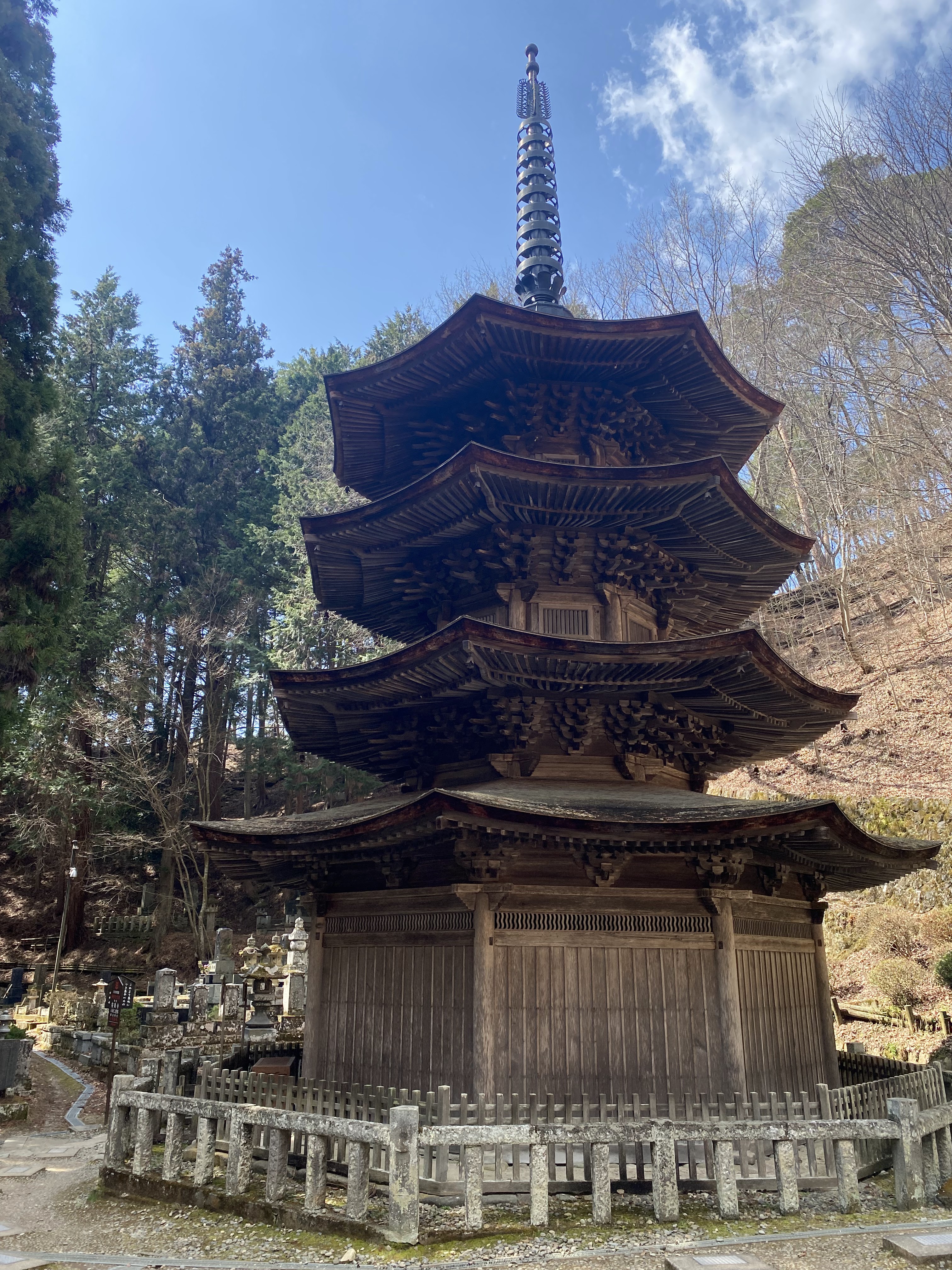
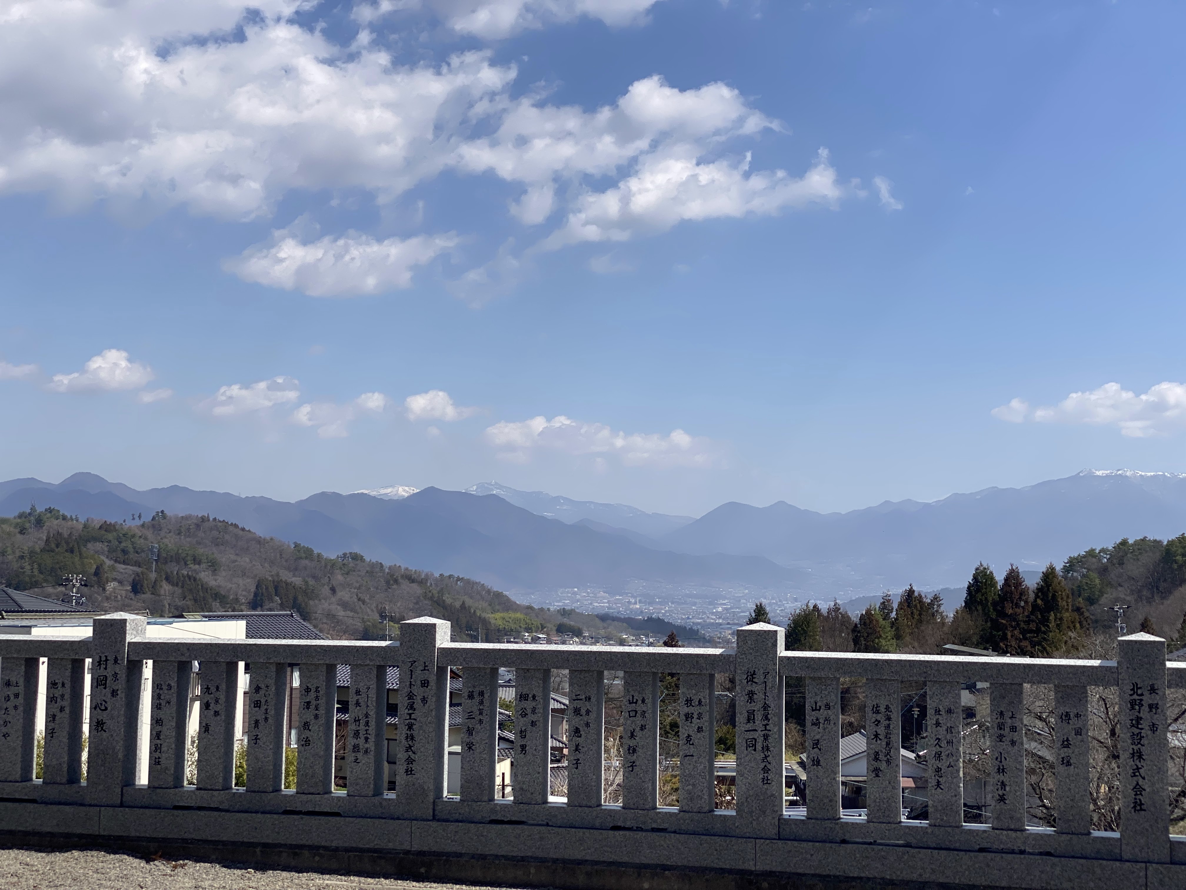
From there to the first sightseeing spot, an ancient temple (Jorakuji) with it's thatched roof. Behind that temple is a small cementery in the forest and a swamp with some nice white flowers. 


It could be a very serene spot, were it not for these two enormous flags outside that squeak on their metal pools in the wind. Again very strong wind today. The flags look nice and all, but I am feeling for the poor people living closeby having to hear their squeaking day and night. 


The next stop was an other temple (Anrakuji), which from a temple perspective seems quite normal, but it has this octagonal 3 story pagode in the forested cemetery behind, which seems to be a unique shape for a pagoda. Well, I guess most of them are square. 


Off to the last temple in town, Kitamuki Kannon ...


... from which's balcony one has a nice view down into the valley of Ueda. 


This concluded the touristy bit of the day. From here a small road went up and up into the mountains behind Bessho onsen, through very small villages. 


My plan was to ride up and over and down to Matsumoto. This part of the road which was destroyed by some landslide, did not put a stop to my plan... 

But soon after turning on to the bigger road (which wasn't much bigger anyway and didn't have any traffic either), I was due (per komoot plan) to turn into yet an other small road, continue uphill, before descending to Matsumoto. However that part of the road turned out to be a gravel road (unexpectedly as Komoot was expecting a paved road). Now, I am not opposed to gravel, but in the middle of really nowhere (no internet, no phone reception), in potential land of bears, needing to ride uphill on a very gravelly gravel road for 3 km didn't sound like a good idea at the moment. Also not knowing if after 3 km the path would again join a "real" road or not. 

At that point I had two options: turn left and join National Highway # 254 to Matsumoto or turn right and ride down the mountain on a small but reasonably good street back to the valley of Ueda. I did choose the second option, as I am pretty convinced that National Highway #254 is full of cars and trucks and tunnels. Doesn't sound like fun. And I had no NEED to go to Matsumoto. Staying on this side of the mountains was just as well. But my curiosity is spiked and I will try this ascent again, however not from Bessho Onsen, but maybe from Aoki where there should be a real (small) street over the mountains to Matsumoto. 

So down it was. In Aoki little by little population and people picked up again and I found a "michi-no-eki" to have lunch and decide where next. I decided to go to Nagano, but to also climb up an other hill closeby. So hill first: 


And then down to the valley, where I should have joined a bicycle path to Nagano (maybe about 30 km)... but the wind was still very strong and even though it would have been slightly downwards to Nagano, the wind was a very strong headwind. So instead I decided to ride river upwards to Ueda (wind in the back, bicycle road below my tires) and take a Shinkansen from there back over the mountain (to be fair: through the mountain) to the Tokyo side of things. 


Good timing allowed me to hop on the next Shinkansen a few minutes after arriving at the platform and getting back to Tokyo. 

Walking (and a bit of cycling) tour of Bessho Onsen:


And from here it is real cycling. After the elevation disaster (misscalculation by Wahoo) yesterday, today I recorded the ride on Strava instead... which is not ideal as it drains the battery unnecessarily:

Saturday 30 March 2024

D1 - Weekend around Bessho Onsen

Route: Takasaki - Megane bridge - Takasaki - Ueda - Bessho onsen
Bicycle: 55 km
Train: 220 km
Total ascent: unknown (wahoo says 3,200+ m which is totally wrong)
Average speed: 14 km/h
Riding time: 3:46 h
Weather: sunny, VERY windy and much warmer than I thought (maybe 25C?)


Since a long time I wanted to visit Bessho onsen. There is a poster in Japan guide forum that often recommends it and it looked like a nice place. But I never found any available lodging. When I planned my upcoming weekends back in January I gave it a try again and found a ryokan at a reasonable price and reserved for 2 different weekends in March and April. 

The initial plan was to ride from Takasaki through a winding mountain street that goes along a decommissioned train line to Karuizawa and then down (and slightly up) to Bessho onsen. But in the early morning train (leaving shortly before 7:00 am from Shinjuku), a fellow cyclist told me that that road was closed due to a typhoon last year. There is an alternative which I feared would be full of cars and trucks (and that premonition turned out right). But anyway, I got off the train in Takasaki and set out into the direction to Karuizawa on my preplanned route. As so often it went along a river on a cycling lane. 


I was cycling against a fierce headwind, which I hadn't expected. The handover from a drinking party with ex-colleagues yesterday probably also didn't help plus it was much warmer than I had anticipated. I was cycling with shorts and had taken off the arms of my Castelli jacket... but still, it was warm. When I finally came to Yokokawa, where the ascent to the mountain pass starts but from where there is also only the big street anymore and no small countryside lanes anymore, I had a short  recon of the route and confirmed that for it to be enjoyable there were too many cars and trucks. So instead I did cycle up the road that is closed. 

I had also gotten quite hungry, but found a good soba restaurant at the bottom of the climb. It turned out that it was at an entrance to the decomissioned train line. One isnt supposed to ride on it by bicycle, and I can see that in more touristy moments it might not be a good idea, but today I was pretty much riding on it alone, just crossing with a few pedestrians until I came to the famous bridge. 


Proably the view from below is more famous though. 


As you can see however from the pictures, the trees were still totally barren (this winter has been long and while not overly cold in total, so far there haven't been a lot of spring days). Even sakura this year is quite late. 

I asked a motorbike rider if he knew if the street was really closed... but he didn't. Maybe I should have continued up a little bit to see for myself. But both his road map and the cyclist in the train told me that it wouldnt be open... and I still needed to get to Bessho onsen. 

Unfortunately with the introduction of the shinkansen between Tokyo and Nagano, the local line that existed has been decomissioned between Yokokawa and Karuizawa. Before and after it exists... but not between. Which also means that the only possibilty to get from Tokyo area (by train) to Karuizawa is taking the shinkansen. But I started with a small local train from Yokokawa back to Takasaki


By shinkansen to Ueda and then back on the bike (the trains to Bessho onsen are infrequent) and it isn't that far anyway, up to Bessho onsen and my ryokan for the night. I arrived there around 17:30, got my room and then rushed to the bath to at least wash off the sweat before having dinner which started at 18:00. In small onsen towns it is often a good idea to reseve hotel with dinner... as there might be no open restuarants around at all. In my rush to wash I did get a quick picture of the rotenburo though. 

After dinner I then took my time to get a proper relaxing bath. I had been contemplating if instead I should be going to the nearby public bath (Oyu) but finally decided against it. After all I had a private bath with rotenburo included in my ryokan. 

The ryokan was run by what seemed to be a group of elderly. I dont think I saw any employee that was substantially below 80 years old. 


Tuesday 19 March 2024

D3 - Over the mountains (twice) to Yoshino

Route: Sakurai - Higashi Yoshino - Yoshino - Gojo - Asuka - Tanzan - Sakurai
Bicycle: 107 km
Total ascent: 1423 m
Average speed: 17.9 km/h
Riding time: 5:57 h
Weather: Cloudy but no rain, ~12 C


I had taken PTO today to do some more riding around Sakurai. On my first ride here in the region I came upon signs of recommended cycling routes on the road. So looked it up, and found a few more around here which I combined into today's ride, plus a few changes made through komoot. Mainly to avoid "big" streets... turned out, I shouldn't have worried about "big" streets. Even the national roads here in this region have little traffic. There is simply not that many places to go to. Very rural, very mountainous and very depopulated. 


Sakurai is right at the bottom of many hills. I took the one up to Tanzan shrine (but didn't go all the way up to the shrine - yet), instead turned left into a short tunnel and then a long uphill section through a small village forgotten by the world. They do have a small tunnel to get to them and a huge tunnel to leave them, both pretty new... and very empty. Lucky for us cyclists.


From there it was a long but pleasant downhill, along the inevitable dam (there are just so many in Japan, is that normal?).


This route was part of the suggested routes from Nara province... but when planning yesterday in komoot I choose even smaller streets, which would really not have been necessary... but wasn't bad either. Riding onwards to my destination of the day, a shrine that came up on Google maps. For me I would say it was a normal shrine as I have seen many... 


... but clearly I was missing the significance of this shrine as there were people visiting it in deep prayer at each section of the shrine, including this waterfall located beyond a small bridge. The shrine stands at the confluence of 2 rivers plus the waterfall... so I can see that this is an important geographical location. 


But I was getting hungry (ate a nut bar, but that wasn't enough) so looked for something to eat... but this region is so remote, that there was no open restaurant anywhere closeby to be found. Luckily however it was a downstream ride along a river until I found about 15 km later in Miyataki a small ryokan that had lunch. Only for me... no other guests. 


Further downstream I came through Yoshino. I had been a few years ago by train from Osaka at the hight of hanami season and only think of Yoshino as a hanami spot... so was surprised to find that it is a very industrial village. Actually not industrial, but a village with a LOT (and I mean A LOT) of saw mills. Every building seemed to be a saw mill, with wood everywhere. Not suprising probably seeing that there are so many forests around. And little else. 

For hanami this year it is way too early. A few weeks ago people were thinking that maybe this week hanami would start (at least down in Osaka/Kyoto/Tokyo), but it got cold again, so hanami is a bit later. In Yoshino probably still 3 weeks to full bloom. 

I continued onwards along the river to Gujo, a place I had ridden through a few years ago on my brompton on the way from Yamatoyagi to Wakayama. From there originally I had planned to take another of the recommended Nara routes on the foothills of the mountain range Mount Kongo, but a few rain drops started to fall, so I decided to play it safe and stay close to the train line... which luckily gets through a very tranquil valley. The rain never really started, so when I had a small stop at a conbini and looking around I saw the tall mountain of Tanzan jinja in the distance. At that point back to Sakurai (or at least to the onsen I wanted to wash off the fatigue) it was probably another 15 - 20 flatish kilometers... but I built up courage, checked the rain radar and decided to instead ride up again to Tanzan shrine, down the other side and only then to the onsen. I am really starting to like climbing up mountains, even though it is hard work and definitely I need several breaks when riding up. 


From there it was a fast decend to the valley, and into the onsen. A super sento between Yamato-Yagi and Sakurai that I have visited before. Also today it was full with families with small children enjoying their time. 

Tomorrow is a local holiday, but weather forecast is rain for the entire day... so I think I'll just do nothing (well, some administrative tasks... and planning the ride for Friday). Weather on the weekend looks pretty bad as well, so I think I will return a day early on Saturday, and hopefully have better weather in Tokyo on Sunday to ride there.

Sunday 17 March 2024

D2 - Akame 48 waterfalls

Route: Nabari - Akame waterfalls - Akameguchi
Bicycle: 13 km
Hiking: 10 km
Train: 55 km
Total Ascent: 440 m 
Average Speed: 17.7 km/h
Riding Time: 45 min
Hiking Time: 2:45 h
Weather: Cloudy and later some rain... but not on me, ~10 C


My first post with "hiking"... an activity I don't really like, because my eyes are normally glued to the ground so I don't actually see the surroundings through which I am hiking. Plus my knee isn't very happy with going downstairs (and yes... this hiking involved a lot of stairs). But Akame 48 waterfalls can be seen hiking only. 

As I was there too late yesterday, I had left the bicycle at Nabari station, so that's where today's ride started. From there up to Akame it isn't very far. I had spotted yesterday a bicycle rack where I left the bike hanging and then set off into the ravine. At the entrance they told me yesterday that it would take 90 min to get to the last waterfall and 90 minutes back. I thought that sounded like a long estimation, but for the way in, it was spot on. I entered the ravine at 9:20 and got to the last waterfall at 10:50... took a 10 min break and had a onigiri I had brought along. On the way back I was however a little bit faster and made it back by 12:15. 75 minutes for the way back. 

The path is along the ravine and follows multiple waterfalls from tiny ones...


... to much bigger ones. 


I had noticed yesterday that in the ravine it was quite cold and today with the weather being already colder, I opted for long cycling trousers and my trusted Castelli ROS jacket. Which was a good combination, allowing for some underlayers to be taken off during the hike and put on later again. 

Overall there were not many people on the hiking path. But one can imagine that in koyo period it will be quite full. Specially until the second major waterfall. After that the hike becomes a little bit more hard (after all, these are waterfalls... so to get to the one above, one needs to walk up and up and sometimes quite steep. So I think a lot of people only make it to the second waterfall... which means they are missing out on what I thought was the nicest of them all, Ninai waterfall (first picture above). 

When I came back I had lunch in a small restaurant in the rather ugly village at the entrance. While eating it started to rain... but luckily rain radar showed (and weather conformed) a break in the rain a little bit later. So I waited it out, then got back on the bike and down to the next train station in Akameguchi, quickly disassembled the bike, headed to the platform, managed to get the bag on top of the bike and jumped on the train that arrived in that moment. Perfect non-planning. 

Back in the hotel I had a long relaxing scrub in the hotels onsen, did put all my cloths in the washing machine and then relaxed in my room. 

Tomorrow it is back to work for at least 1 day, but in Osaka. Tuesday weather seems to be fine, so I will take PTO. Wednesday is the local holiday... but it seems it will rain... so maybe some museum time? Thursday again rain, so I will work but Friday looks nice and sunny, albeit cold. 

Saturday 16 March 2024

D1 - Muro temple and art

Route: Sakurai - Uda - Muro - Akame - Nabari
Bicycle: 53 km
Train: 30 km
Total ascent: 1215 m
Average speed: 14,1 km/h
Riding time: 3:47 h
Weather: sunny and early spring, probably around 16C (but Wahoo thinks it was -124 C ...)


Next Wednesday is a local holiday and originally our boss was going to come to Japan next week as well, likely to Osaka. So quite a long time ago, I think probably shortly after my winter ride here in inner Nara prefecture, I reserved a hotel in Sakurai to continue exploring this area that I like so much. 

To have extra time I already arrived yesterday evening by Shinkansen and local trains from Tokyo. So today I could start immediately with the ride. 

I had bookmarked two locations closeby based on recommendations from the Japan Guide Forum

  • Muro Art Forest
  • Akame 48 Waterfall's

But it turned out that I would manage only the Art Forest. But let’s go in order.

I planned a route yesterday evening which turned out to be on very nice and very quiet roads once I turned away from the state road after about 7,5 km, and actually I could have enjoyed even more rural roads as most of the steep part of the state road had a village road in parallel , which stupidly I didn’t take. But once away from there quite soon I came to a long lake with a small road that had hardly any traffic. It was even a recommended route from Nara prefecture and well indicated.

The route went to Muro, where my first google pin was. But while cycling there I noticed that everywhere there were indications of Muro temple. So I decided to give it a visit. It starts like any normal temple with a big gate...


... then goes up what seems to be a lot of stairs ...


... until you realize, beyond the pagoda ...


... that ... 


... the stairs hadn’t even yet started in serious.


Only at the end of these long and somewhat irregular stairs is the Inner temple with a nice view over the valley.

The village itself was very traditional and surprisingly touristic. 

But could easily be host to a TV series of Showa or even Taisho period.

I had a very good vegetable lunch in a traditional ryokan at the entrance to the temple before continuing and exploring the Art forest.

This art installation was quite popular with young people (in their 20s and 30s). Only a few people above that age range had also made it to the park. Probably all the pictures end up on Instagram... except mine... which end up here on blogger for no one to read. 


Originally my plan was to then go to the 48 waterfalls and ride back to Sakurai... but with all this sightseeing it had gotten quite late. I still did cycle onwards to the waterfalls but when I arrived it was already after 15:00 and I would only have been able to walk a part of the trail. Apparently it takes 90 minutes to walk to the farest waterfall and 90 minutes back. So a real hike. But that will be for tomorrow. I hadn't a specific plan, apart from leaving the bicycle at a train station in that area and continue exploring from there... so now I even know what to explore. Tomorrow weather is going to be somewhat worse... so I hope to get an early start to see the waterfalls and then decide if just riding back by train, riding back the same way I cycled up there today or explore somewhere further. No pressure. 

But it is good that finally it is warm enough to again combine cycling and tourism. Back in January it was definitely too cold for that. 

From the non-waterfalls I cycled down to Nabari, which resulted to be already in Mie prefecture and went to a super sento there. There were some more rural onsen on the way, but both I saw were already closed (and this was before 16:00). Probably in the afternoon/evening they are only for staying guests. 

After a good soak I left the bicycle in the parking lot of Nabari station, put my 220 yen into a un unmaned box and took the train back to Sakurai. Although this region is very rural, there are surprisingly many trains. About 4 or 5 every hour towards Osaka and probably a similar number towards the coast of Mie prefecture. 


Monday 12 February 2024

D3 - Three lakes in one ride

Route: Mito - Hinuma lake - Kitaura lake - Kasumigaura lake - Tsuchiura
Bicycle: 107 km
Train: 85 km
Total ascent: 252 m
Average speed: 18,9 km/h
Riding time: 5:40 h
Weather: sunny but cold , 8 C


For the last day of this 3 day weekend I cycled my way back from Mito to Tsuchiura but touching on all 3 lakes that are in the area. 

Lake #1: Hinuma

The smallest of the 3 lakes but also this one with at least for some part a bicycle lane. From there through this countryside which is very much dedicated to vegetables and probably also some fruits.  For sure strawberries, but I think generally vegetables. Now it was still too early for most of them but the plastic greenhouses were already ready as were the fields.


The strawberries however were already on sale. There was a strawberry farm that made heavy publicity along the road so I decided to stop and join the queue of people buying strawberries in all sizes. Well , generally quite big sizes. I got for 700 Yen a small box of strawberries to eat on the spot. And while they looked nice , the taste was quite thin. For me strawberries are a fruit of early summer. Maybe May or so, but here it is typical of Xmas and winter in general. Obviously they grow in greenhouses but still I think the European strawberries in May are much more tasty. 

Lake #2: Kitaura

This is a very long but not very wide lake running practically parallel to the sea but separated from it by some hills. Quite a layer back atmosphere. I wonder how long a ride around it would be… and got the answer from Komoot: 70 km. 

There were practically no other cyclists along the lake. The road around it is small just for the local fishermen and farmers and their small cars. Also the villages are quite small but passing over a bridge in the upper middle of the lake there was the one and only restaurant in the area. An old style village restaurant that served a very well fried Hirekatsu. Tasty! 

Lake # 3: (the good old) Kasumigaura

Through more layers back and very slightly ondulating terrain I came over to Kasumigaura. If I remember correctly the second largest lake in Japan, just surpassed by Lake Biwa. 

I had a crepe at the roadside station by the big bridge and decided to go from there back to Tsuchiura instead of adding the northern part of the lake to the itinerary as it was getting late. I made it back to Tsuchiura well before dark and went to an onsen I had visited a few weeks ago, to wash,  relax and eat before now taking the train back to Tokyo. 

Sunday 11 February 2024

D2 - Into the rolling hills around Mito

Route: Into the hills between Mito and Motegi
Bicycle: 98 km
Total ascent: 800 m
Average speed: 16,7 km/h
Riding time: 5:51 h
Weather: sunny but cold , 8C


For this second day, I went to explore the rolling Hills between Mito and Motegi. Even more remote than the area between Kasumigaura and Mito that I came through yesterday. Some small villages, some of them still with a lot of traditional houses, rolling hills, Some fields, forests, small, rivers, and surprisingly a few, I think two to be precise, groups of cyclists.When I looked up yesterday, if there any recommended roots here in the area, I couldn’t find anything on the various websites I know that recommend rides around Japan.It isn’t actually that far from Tokyo, but the area is probably not interesting enough for someone to come from Tokyo all the way here. There are better mountains much closer to Tokyo and while the rolling hills are nice, it’s also not spectacular and the area is relatively hard to reach.


While being out there shortly before 12 I got really hungry and realized that I was in the middle of nowhere. Actually close to Village, but there was nothing in that village. Luckily Google maps showed me a soba restaurant a few kilometers further on that was so popular that I even needed to wait. During lunch, I decided to make the right a little bit easier, which was a good decision as it was already 2 o’clock when I restarted the ride and I wanted to get to the onsen prior to it getting dark.


A few of the plum trees already are in full bloom, and some of them have a really strong, sweet scent. 


But mostly it is still too early. It is still winter, spring is still an idea of the future.


When planning this weekend yesterday while coming here by train, I saw a super sento close to Mito which had a very nice picture and it seemed that you can look outside into the countryside while soaking in the hot water. And yes, that is really what is happening. You don’t have an actual view of the landscape, But you can look into some bamboo trees, and some other shrubs, instead of just looking at a wall.